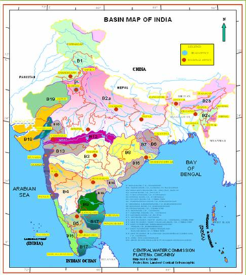
India - Rivers
In India, the rivers
can be divided into two main groups:
1.
Himalayan Rivers
2.
Peninsular Rivers
(1)Himalayan Rivers of
India : The Himalayan rivers can
be broadly divided into three major river systems.
The Indus System
 It has a total length
of 2880 km (709 km in India). Rises in Tibet (China) near Mansarovar Lake.
It has a total length
of 2880 km (709 km in India). Rises in Tibet (China) near Mansarovar Lake.
In Jammu and Kashmir,
its Himalayan tributaries are: Zanskar, Dras, Gartang, Shyok, Shigar, Nubra,
Gilgit, etc.
Its most important
tributaries, which join Indus at various places, are: Jhelum (725 km), Chenab
(1800 km), Ravi (720 km), Beas (470 km) & Sutlej (1050 km).
Sources: Jhelum from
Verinag (SE Kashmir), Chenab from Bara Lacha Pass (Lahaul-Spiti, H.R), Ravi
from Kullu Hills near Rohtang Pass in H. R, Beas from a place near Rohtang Pass
in H.E and Satluj from Mansarovar - Rakas lakes in W. Tibet.
In Nari Khorsan
province of Tibet, Satluj has created an extraordinary canyon, comparable to
the Grand Canyon of Colorado (US).
According to the Indus
Water Treaty signed between India and Pakistan in 1960, India can utilize only
20% of the total discharge of Indus, Jhelum and Chenab.
The Ganga System
It is 2525 km long of
which 1450 km is in Uttarakhand and UP, 445 km in Bihar and 520 km in West
Bengal.
The Ganga, the head
stream is constituted of two main rivers - Bhagirthi and Alaknanda, which
combine at Devprayag to form Ganga.
Before Alaknanda meets
Bhagirthi at Devprayag, Mandakini meets Alaknanda at Rudraprayag.
Sources: Bhagirthi
from Gaumukh, Alaknanda from Badrinath, Mandakini from Kedarnath (all from
Uttarakhand).
Yamuna (1375 km) is
its most important tributary (on right bank). It rises at the Yamunotri glacier
in Uttarakhand. It runs parallel to Ganga for 800km and joins it at Allahabad.
Important tributaries of Yamuna are Chambal (1050 km), Sind, Betwa (480 km) and
Ken (all from south).
Apart from Yamuna,
other tributaries of Ganga are Ghaghra (1080 km), Son (780 km), Gandak (425
km), Kosi (730 km), Gomti (805 km),
Damodar (541 km). Kosi is infamous as 'Sorrow of Bihar', while Damodar gets the
name 'Sorrow of Bengal' as these cause floods in these regions.
Hooghli is a
distributory of Ganga flowing through Kolkata.
The Brahmaputra system
It has a total length
of 2900 km. It rises in Tibet (from Chemayungdung glacier), where it is called
Tsangpo, and enters the Indian territory (in Arunachal Pradesh) under the name
Dihang.
Important Tributaries:
Subansiri, Kameng, Dhansiri, Manas, Teesta.
In Bangladesh,
Brahmaputra is known by the name of Jamuna while Ganga gets the name Padma.
Their combined stream is known as Padma only. Meghna is the most important
distributory before it enters the Bay of Bengal.
The combined stream of
Ganga and Brahmaputra forms the biggest delta in the world, the Sundarbans,
covering an area of 58,752 sq. km. Its major part is in Bangladesh.
On Brahmaputra is the
river island, Majuli in Assam, the biggest river island in the world.
Brahmaputra, or the
Red River, is navigable for a distance of 1384 km up to Dibrugarh and serves as
an excellent inland water transport route.
(2)Rivers of the
Peninsula in India
Different from the
Himalayan rivers because they are seasonable in their flow (while Himalayan
rivers are perennial).
They can be divided
into two groups:
A. East Flowing Rivers
of India (or Delta forming rivers)
Mahanadi River (858
km) : Rises in Raipur
distt. in Chhatisgarh. Main tributaries: lb, Seonath, Hasdo, Mand, Jonk, Tel,
etc.
Godavari River (1465
km) : Also called Vriddha
Ganga or Dakshina Ganga. It is the longest peninsular river. It rises in Nasik.
Main tributaries: Manjra, Penganga, Wardha, Indravati, Wainganga, Sabari, etc.
Krishna River (1327
km) : Rises in Western
Ghats near Mahabaleshwar. Main tributaries: Koyna, Dudhganga, Panchganga,
Malprabha, Ghatprabha, Bhima, Tungabhadra, Musi, etc.
Cauvery River (805 km) : It is the largest
peninsular river (maximum amount of water). Infact, it is the only peninsular
river which flows almost throughout the year. Known as the 'Ganga of the
South'. It rises from the Brahmagir range of Western Ghats. Main tributaries:
Hemavati, Lokpawni, Shimsa. It is less seasonal than others as its upper
catchment area receives rainfall during summer by the S.W monsoon and the lower
catchment area during winter season by the retreating N.E. monsoon. Its 90% -
95% irrigation and power production potential is already being harnessed.
Swarnarekha River (395
km) and Brahmani (705 km) : Rises from Ranchi
Plateau.
B. West Flowing Rivers
in India
Narmada River (1057
km) : Has only l/10th
part in Gujarat. Rises in Amarkantak Plateau and flows into Gulf of Khambat. It
forms the famous Dhuan Dhar Falls near Jabalpur. Main tributaries: Hiran,
Burhner, Banjar, Shar, Shakkar, Tawa, etc.
Tapti River (724 km) : Rises from Betul
distt in MR Also known as twin or handmaid of Narmada. Main tributaries: Purna,
Betul, Arunavati, Ganjal, etc.
Sabarmati River (416
km) : Rises from
Aravallis in Rajasthan.
Mahi River (560 km) : Rises from Vindhyas
in MR
Luni River (450 km) : Rises from
Aravallis. Also called Salt River. It is finally lost in the marshy grounds at
the head of the Rann of Kuchchh.
Sharavati is a west
flowing river of the Sahyadris. It forms the famous Jog or Gersoppa or Mahatma
Gandhi Falls (289 m), which is the highest waterfall in India.